Upper Dolpo Trekking

Duration25 Days
Trip GradeStrenuous
CountryNepal
Maximum Altitude5,309 m
Best TimeSpring and Autumn

Upper Dolpo Trekking is a unique and challenging adventure to the Upper Dolpo region of Nepal. This trek offers views of the breathtaking snow-capped peaks, rich cultural experiences, and a sense of adventure in the remote northwestern part of the country.

Highlights of Trek 

  • Breathtaking views of the landscapes, including arid deserts, lush vegetation, and dramatic mountains.
  • Authentic experience of Tibetan Buddhism and Bon culture of the Upper Dolpo Region.
  • Exploration of the ancient monasteries and hermitages for spiritual insights.
  • A glimpse of the spiritual history of the area through the preserved Buddhist texts and manuscripts.
  • Trekking through the Shey Phoksundo National Park, experiencing the pure atmosphere and spotting wildlife like blue sheep and the elusive snow leopard.
  • Crossing the challenging pass, Kang La, that has heights above 5,000 meters.
  • Visiting the picturesque villages like Dho Tarap and Shey for insights into local traditions and history.
  • Learning about Buddhist architecture and culture through Mani walls, Kanies, and Chortens.
  • Visit the stunning turquoise lake called Shey Phoksundo Lake and capture some moments.
  • See the caravans of yaks, mules, and horses walking on the trails of the Upper Dolpo Nepal.
  • Peaceful and crowd-free trekking experience in between untouched natural beauty.

Overview of the trek

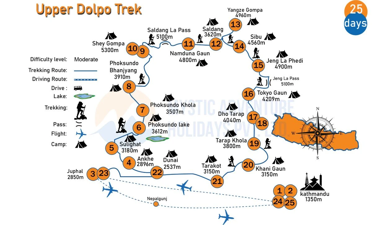
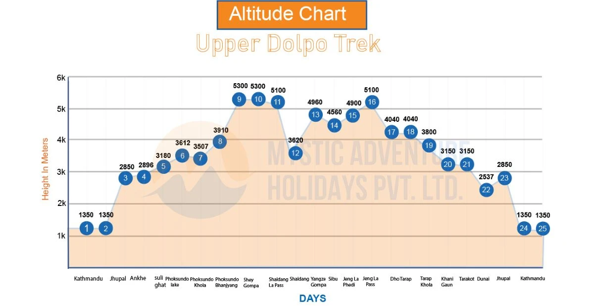
The Upper Dolpo Trekking itinerary starts with your arrival in Kathmandu. Then, you will head towards the Upper Dolpo region. On the way to the highest elevation of the trek, i.e., Kangla Pass, you will cross several destinations like Dunai, Akhe, Sulighat, Phoksundo Lake, and Phoksundo Bhanjyang. 

On the ascending journey, you will pass through places like Shey Gompa, Namduna Gaun, Saldang, Yanze Gompa, Jengla Phedi, Tokyo Gaaun, Dho Tarap, Khani Gaun, and Jhuphal. This trek itinerary culminates with your departure to your desired destination.

During the trek, you will witness the views of the snowcapped peaks like Dhaulagiri I, Churen Himal, Kanjirowa South, Lhashama, Sita Chuchura, Kanjirowa South, Dogari Himal, and many more. 

The trek also offers the opportunity to immerse oneself in the Tibetan Buddhist and Bon cultures in the remote settings. The traditional villages, monasteries like Shey Gompa, and festivals reflect the unique culture of the Upper Dolpo region. There you can gain cross-cultural understanding along with wilderness. 

Major Highlights of the Trek

  • Sightseeing in Kathmandu

The important highlight of the Upper Dolpo Trek is sightseeing in Kathmandu city. Kathmandu city is an administrative capital of Nepal and also a center of Nepal's history, art, culture, and economy for centuries. 

The historical sites inside Kathmandu city are Pashupatinath Temple, Boudhnath Stupa, Kathmandu Durbar Square, and Swayambhunath. These sites showcase the unique cultural blend and architectural achievements of the Newari peoples. 

  • Jhuphal 

Jhuphal is the starting and ending point for the Upper Dolpo Trekking. It is located in the Upper Dolpo region at an elevation of 2,475 meters. The area of the Jhuphal is heavily influenced by the influence of Tibetan culture. By visiting there, you can gain some insights about the culture.

  • Phoksundo Lake

Phoksundo Lake is a stunning alpine freshwater lake situated in the Shey Phoksundo National Park of Nepal. The lake is part of the Upper Dolpo Trekking. Trekkers and travelers are attracted to this lake because of its breathtaking turquoise color.

The lake is the second largest lake in Nepal. It is situated at an elevation of 3,611.5 meters (11,849 feet) above sea level. The depth of Phoksundo Lake is approximately 136.20 meters (446.9 feet). Near the lake, there is Nepal's highest waterfall (167 meters), called Phoksundo Waterfall or Suli Gad Waterfall.

  • Phoksundo Khola

Phoksundo Khola is a river or stream that flows from the Phoksundo Lake in the Dolpo region of Nepal. It drains from the lake and mixes up in the Suligad River. From the river area, you can see the vistas of the peaks like Kagmara Peak, Chhamlang Peak 6, and Dhaulagiri and Annapurna Range.

  • Kang La pass

Kang La Pass is an important landmark and a challenging mountain pass in the Annapurna region of Nepal. It is part of the Upper Dolpo Trek, and also the highest elevation reached during the trek is 5,306 m.

Crossing the Kang La pass is difficult due to its high altitude and steep terrain. However, trekkers still have to cross it because it offers stunning views of the Annapurna II, Gangapurna, Tilicho Peak, Khangsar Kang, Lamjung Himal, Manaslu, Dhaulagiri, and more.

  • Shey Gompa

Shey Gompa is an important Buddhist monastery located in the Shey Phoksundo rural municipality of Nepal. The elevation level at which the monastery is located is approximately 4,200 meters. It was established in the 11th century.

The Shey monastery is popular because it is associated with the Kagyu sect of Tibetan Buddhism. The other reason behind its popularity includes views of the peaks like Knajiroba Himal, Ghyuthumba, Matathumba, Api Himal, Dhaulagiri, Manaslu, and more.

  • Yangze Gompa

Yangze Gompa is an ancient Bon-Po monastery situated in the upper Dolpo region of Nepal. The altitude level at which the monastery is situated is 4,960 meters (16,267 feet). It is considered one of the oldest monasteries in Nepal and showcases the historical and spiritual heritage of the region.

  • Jeng La Phedi

Jeng La Phedi is an important stop on the Upper Dolpo trekking trail. It is located at an elevation of 4,900 meters (16,072 feet) above sea level. The Phedi is exactly below the Jeng La Pass. From the Phedi, you can see the breathtaking views of the surrounding mountains and valleys.

The area of the Jeng La Phedi is surrounded by the Himalayan fauna, home to several wildlife, including snow leopards, blue sheep, black bears, musk deer, Tibetan wolves, and more.

  • Tokyu Gaun

Tokyu Gaun is a small village in the Tarap Valley of the Upper Dolpo Region. It is located at an elevation of approximately 4,209 meters (13,747 feet). The village offers views of the breathtaking landscapes and a glimpse into traditional Tibetan culture.

There are several ancient monasteries including Tokyu Monastery from where you can learn about spirituality and the monk’s way of living. In addition, you can explore the architecture of village houses, prayer flags, and Mani walls in the Tokyu gaun.

  • Dho Tarap

Dho Tarap is a valley located in the Dolpo region of Nepal. It is located at an elevation of approximately 4040 m (13,255 ft) above the mean sea level. In the valley, there are three culturally rich villages named Dho, Tokyu, and Lang. From the valley, you can see the vistas of the snow-capped mountains, alpine meadows, and rivers. 

Why us for the Upper Dolpo Trekking?

3S: Safety, Success, and Satisfaction

Booking an Upper Dolpo Trekking packages with Mystic Adventure Holidays offers superior service and benefits. Here's why: 

  • Client Safety: Our trips are organized with the utmost safety in mind.
  • Best Price Guarantee: Ensuring you get the best value.
  • Free Transfers: Complimentary airport-to-hotel and return transfers in a private vehicle.
  • Expert Guides: Trained, government-licensed local guides with extensive route knowledge.
  • Support for Locals: Helping local communities earn a living through tourism.
  • Health Monitoring: Oximeters to monitor oxygen levels during high-altitude treks.
  • Medical Preparedness: Guides equipped with medical kits to handle any situations that may arise. 
  • Essential Gear: Arrangements for sleeping bags and down jackets.
  • Free Storage: Secure storage at our office for extra luggage during your tour.
  • Convenience: Duffel bags for transferring items to be carried during the journey.
  • Porter Service: A free porter to help carry your heavy bags.
Itinerary

At Mystic Adventure Holidays, our intention is always to follow the Upper Dolpo Trekking Itinerary. However, due to the nature of travel, we may need to make slight changes because of unforeseen circumstances such as weather-related cancellations or delays of domestic flights, natural disasters like landslides, newly enacted laws, political unrest, or trekkers' health issues, including altitude sickness. While the itinerary is brief and fixed, it also includes flexible areas. Therefore, we advise travelers to allow a few extra days in Nepal.

We highly recommend that you arrive one day before the trip starts to rest and purchase any necessary clothing, gear, and equipment for the hike. You can also use this extra day for a sightseeing tour in Kathmandu, acclimatizing, or rescheduling international flights in case of potential weather delays or domestic flight cancellations.

We appreciate your flexibility and look forward to providing you with an unforgettable adventure!

It is our regular day-to-day itinerary if you are looking for a customized itinerary. Don't hesitate to contact us.

Trip PlanExpand all

Kathmandu, Nepal's capital city, is in a valley surrounded by picturesque green hills on all sides. Assume you enter through the flight (Airways). The Mystic Adventure Holidays representative will be in the airport terminal with our company flag. Nepali CultureThe traditional greeting is to press one's palms together in front of the chest and utter "Namaste" (which means "I greet the god within you"). Depending on the level of the person you are welcoming, you may greet them with a nod of the head or a bow, as well as khadas (Buddhist shawls) or garlands and a crimson tika (tilak) on your forehead. Garlands and tilaks are used in Nepal to signify honor when someone comes.to wish you a hearty welcome. After welcoming you, our representative will drop you off at your hotel and assist you with check-in. Our representative will greet you at your location if you come by road.

There will be no activities scheduled for you. You can relax, and if you wish to explore, you may do so on your own. Overnight at a hotel in Kathmandu

Before visiting Nepal, you may have learned how to greet someone with a 'Namaste' or thank someone with a 'Dhanyabad'. However, it's important to note that Nepal is an ancient civilization with its own set of ideologies and mannerisms. Here are some social etiquettes specific to Nepal that can help you avoid being disrespectful or humiliating in public. Nepal's roads are unpredictable. Roads are usually congested, resulting in numerous traffic backups. Most places lack traffic lights, forcing drivers to rely on hand gestures from police officers.

Visit religious places and UNESCO-listed places.

  • Swoyambhu Nath Stupa
  • Boudhnath Stupa,
  • Pashupatinath Temple,
  • Kathmandu Durbar Square,
  • Patan Durbar Square
Max Altitude: 1,350 m Meals: Welcome dinnerAccommodation: Apsara Boutique HotelDuration: 30-45 minDistance: Approx. 6 km

Today's sightseeing tour in Kathmandu will give you a good insight into Nepali art and architecture. You will visit UNESCO World Heritage Sites like Pashupatinath Temple, Boudhnath Stupa, Kathmandu Durbar Square, and Swayambhunath. All of these monuments hold great importance in the history of Nepal. Later in the evening, you will meet with the trek guide and have a quick briefing session about the trek.

Max Altitude: 1,350 m Meals: Breakfast onlyAccommodation: Apsara Boutique HotelDuration: Full day

Flights to Jhupal leave early in the morning from Kathmandu.  The crew will be waiting with the necessary camping equipment in Jhupal. On the first day, hike for around three hours to Dunai, which is the administrative capital of Dolpo Region.

Max Altitude: 2,850 m Meals: Breakfast, Lunch, DinnerAccommodation: lodgeDuration: 45 min-1 hr flight & 3 hrs trekDistance: Approx. 294 km aerial & Approx. 12 km road

Today the trail takes us upwards through the Thulo Bheri Valley before entering the Phoksundo River Valley.  There are a couple of villages on the way and walnut groves to admire. And naturally, there are the mountains—Kagmara Peak is on display.  Finally, the trail goes down through dense jungle-like vegetation to Ankhe.

Max Altitude: 2,896 m Meals: Breakfast, Lunch, DinnerAccommodation: Tent CampDuration: 5-6 hrsDistance: Approx. 18 km

Today’s trail takes us up and down through forests and over a grassy slope above the river.  Following the trail downwards, carefully descend a stone staircase to the river bank and on to Sulighat.

Max Altitude: 3,180 m Meals: Breakfast, Lunch, DinnerAccommodation: Tent CampDuration: 5 to 6 hrsDistance: Approx. 20 km

Today we reach the beautiful, clear waters of Phoksundo Lake. But first, we follow the valley floor, passing the Phoksundo and Pungmo rivers and pine forests.  From the top of a high ridge, we get our first glimpse of the lake shimmering in the sun below us. Here we also find one of the highest waterfalls in Nepal.  The trail then descends through birch forests to the pretty village of Ringmo on the edge of Phoksundo Lake.

Max Altitude: 3,612 m Meals: Breakfast, Lunch, DinnerAccommodation: Tent CampDuration: 3-4 hrsDistance: Approx. 7-8 km

Today, leave the lake by following the trail to the west, across the wooden bridge-like structures, until we reach a meadow leading to the Phoksundo Khola flood plain.  The trail takes us over boggy marsh ground through the valley to the riverbank, where we will overnight. 

Max Altitude: 3,507 m Meals: Breakfast, Lunch, DinnerAccommodation: Tent CampDuration: 5 hrsDistance: Approx. 7-8 km

Today, walk through a glacial valley to the confluence of the Phoksundo Khola and another stream, marked by an old wooden bridge.  Climbing northeast, we reach a sheep meadow and onto a steep ravine. Climbing up here is hard, but we need to reach another valley, where we will eventually cross the Kang La Pass after having a good night’s rest.

Max Altitude: 3,910 m Meals: Breakfast, Lunch, & DinnerAccommodation: Tent CampDuration: 5-6 hrsDistance: Approx. 10 km

We start the day with a very strenuous climb to the top of the Kang La Pass.  When at the top, there are great views of the valley below. Now the trail descends to the valley floor on a steep trail.  We follow the banks of the river, crossing and recrossing the icy waters. We can see mud caves lining the hills, which look down on the river.  Before reaching Shey Gompa, we walk through meadows filled with yaks, sheep, and mountain goats.

Max Altitude: 5,300 m Meals: Breakfast, Lunch, & DinnerAccommodation: Tent CampDuration: 7-8 hrsDistance: Approx. 18 km

Today we need to take an acclimatization day as yesterday brought us a 590 m elevation gain between Phoksundo Bhanjyang and Shey Gompa.

There is plenty of time to explore the Gompa, which is of the Bon religion. This is similar to Buddhism but dates from pre-Buddha times. In this area, there is also the unique Crystal Mountain. Its name comes from the fact that it has quartz and marine fossils embedded in its cliffs.

Max Altitude: 5,300 m Meals: Breakfast, Lunch, & DinnerAccommodation: Tent CampDuration: Full day

Today we walk through juniper trees into a canyon where the trail winds over rocks and loose stones until we reach the top of Saldang La Pass.  The descent over the other side is also tiring. Today, we can see nomadic herders with their yaks and sheep. Arriving at Namduna Gaun, where we will spend the night, there is time to explore the red monastery built below a gorge cliff. 

Max Altitude: 4,800 m Meals: Breakfast, Lunch, DinnerAccommodation: Tent CampDuration: 6 -7 hoursDistance: Approx. 15 km

Today the trail takes us through barren mountains to reach Saldang village on a plateau above the Namga Khola.  This is the largest village in the inner Dolpo area and is spread over a long (2 km) slope. Interestingly, it is not just one, but five villages, combining around 80 houses.  Being strategically placed on the trade route to Tibet probably explains why there are so many houses here. 

Max Altitude: 3,620 m Meals: Breakfast, Lunch, DinnerAccommodation: Tent CampDuration: 5-6 hrsDistance: Approx. 16 km

The terrain is barren as we follow the Nagaon Khola through the villages of Marang and Ki.  Crossing a tributary of the Panzang River a couple of times, we reach another Bon monastery in Yangze Gompa.

Max Altitude: 4,960 m Meals: Breakfast, Lunch, DinnerAccommodation: Tent CampDuration: 4 hrsDistance: Approx. 12 km

Today we pass terraced fields, mani walls (walls with prayers carved into stones), stupas, Chorten, and a monastery to Namdo village. This is another prosperous village of around 60 houses and sits high above the Nam Khong Khola. We walk for another 2 hours to camp at Sibu. 


Max Altitude: 4,560 m Meals: Breakfast, Lunch, DinnerAccommodation: Tent CampDuration: 6 - 7 hrsDistance: Approx. 18 km

Today again, we will most likely see caravans of yaks as we walk east and then ascend to a grazing pasture below the Jeng La Pass. 

Max Altitude: 4,900 m Meals: Breakfast, Lunch, DinnerAccommodation: Tent CampDuration: 5-6 hrsDistance: Approx. 14 km

Since we are starting from Jeng La Phedi at 4,900 m, we are only ascending 200 m to cross the pass (5,100 m).  From the pass, we see the amazing sight of the north face of the Dhaulagiri Massif. Crossing the pass, the trail descends along the rough ground to the Tarap Valley and the monastery in Tokyu.

Max Altitude: 4,209 m Meals: Breakfast, Lunch, DinnerAccommodation: Tent CampDuration: 6-7 hrsDistance: Approx. 14 km

Today we enter a different landscape as marshes and grasses line the river banks.

Max Altitude: 4,040 m Meals: Breakfast, Lunch, DinnerAccommodation: Tent CampDuration: 4 hoursDistance: Approx. 7-8 km

On this rest day, we spent the day in Dho Tarap.  Here there are around 40 houses of the main people known as Magars, a hill tribe of Nepal. There are also some Tibetans living here, and Buddhism is still a big feature of the area. There is also a Bon Gompa a short distance from the village. Today, explore the village, Gompa, and the surrounding area. 

Max Altitude: 4,040 m Meals: Breakfast, Lunch, DinnerAccommodation: Tent CampDuration: Full Day

The trail takes us through juniper and wild roses towards a wide valley, narrowing to a gorge.  Again, we see herds of sheep before reaching the confluence of the Tarap Chu and Lang Khola rivers.  We camp near the Tarap River. 

Max Altitude: 3,800 m Meals: Breakfast, Lunch, DinnerAccommodation: Tent CampDuration: 6-7 hrsDistance: Approx. 14 km

Today we meet many local people on the way, mainly taking their herds to lower pastures.  We walk over stone slabs, logs, and rough bridges, and perhaps even through the river itself!

Max Altitude: 3,150 m Meals: Breakfast, Lunch, DinnerAccommodation: Tent CampDuration: 4-5 hrsDistance: Approx. 7-8 km

Today, follow the path to Lalberi village and on through forests and a gorge until we are following the river again.  There is another monastery we can visit today, sitting on a hill above the Bheri River. Tonight we camp at Tarakot as there is no suitable camping place between Tarakot and Dunai, which we will reach tomorrow. And therefore, it is also a short walking day.

Max Altitude: 3,150 m Meals: Breakfast, Lunch, DinnerAccommodation: Tent CampDuration: 5-6 hrsDistance: Approx. 12 km

Today’s hiking is relatively easy, through a pine-lined gorge and along the Bheri River to reach Dunai. 

Max Altitude: 2,537 m Meals: Breakfast,Lunch,DinnerAccommodation: Tent CampDuration: 5 to 6 hrsDistance: Approx. 12 km

Today is the final day of the trek, with a short, easy walk to Jhupal.

Max Altitude: 2,500 m Meals: Breakfast, Lunch, & DinnerAccommodation: Tent CampDuration: 2 to 3 hrsDistance: Approx. 5-6 km

This morning, take an early morning flight from Jhupal to Nepalgunj, then connect by another flight to Kathmandu.  

Max Altitude: 1,350 m Meals: Breakfast, Lunch, & DinnerAccommodation: Apsara Boutique HotelDuration: 1 hrDistance: Approx. 294 km

Here concludes the journey. Today, it is time for you to return home. Our Mystic Adventure Holidays airport representative will send you off 3.5 hours prior to your arrival in Kathmandu, following a traffic jam that we observe, and upon your arrival. will assist you with check-out and transport you to the airport before the time of your flight. The time has come to bid Dieu.

We dress you in traditional khada in anticipation of your safe journey and good fortune.  It's time to say farewell. We put you in traditional khada for good luck and a safe flight. 

Thank you so much for giving me a chance to plan your trip. I am glad to be part of your Nepal journey. I hope you have a wonderful time at Nepal. see you again, Nepal, once, but never enough. Have a safe flight back to your home. Best wishes from Mystic Adventure Holidays.

Max Altitude: 1,350 m Meals: Breakfast onlyDuration: 30-45 minDistance: Approx. 6 km
Unable to locate what you're seeking?Reach out to our travel experts.
Customize Trip
Cost Details
Included
  • Airport pick-up and drop
  • Hotel accommodation with breakfast in Kathmandu.
  • City sightseeing by private vehicle, including all entrance fees and tour guide
  • Meals during the treks (daily, three meals and three teas or coffees)
  • best available teahouse/lodge accommodations during the trek are shared.
  • Seasonal fruits during the treks
  • Welcome and Farewell dinner
  • Highly experienced English-speaking friendly, helpful guide and porters (one porter for two trekkers), including all their salary, food, accommodation, transportation, equipment, and accidental insurance.
  • Flight ticket from Kathmandu to Nepalgunj
  • Down jacket, Sleeping bag, duffel bag, trekking map (Note: Down jacket and sleeping bag are the company's property and need to be returned after the completion of the trip. (You can take a duffel bag as a souvenir.)
  • Camping equipment 
  • poter for one pax, one person
  • Mystic Adventure Holidays' T-shirt
  • Trip achievement certificate
  • First-aid medical kit (carried by your leader)
  • Dolpo Trekking entry permit
  • All government taxes and service charges
Excluded
  • Nepal Visa Fee
  • International Flights Ticket
  • Excess baggage charge(s)
  • Extra accommodations are available in Kathmandu due to various reasons, like early arrival, late departure, or early return from the mountain. 
  • Lunch and Dinner in Kathmandu
  • Travel and rescue insurance ( Mandatory)
  • Personal expenses like mobile calls, laundry, alcoholic beverages, electricity usage, extra porters, boiled water, hot showers, etc.
  • Tips for guide(s), porter(s) and driver(s)
  • Compulsory to Tips For Guide and supporting staff (minimum . 10% of Paying amount)
  • All the expenses, i.e., those not mentioned in the included section,.
Route Map
Upper Dolpo Trekking map
Altitude Chart
Upper Dolpo Trekking altitude chart
Dates & Availability

Are you interested in planning a custom trip now?

Essential Info

Difficulty level of the trek

The difficulty of the Upper Dolpo Trekking is graded as challenging. There are several factors contributing to the challenges. For example, the trek covers a distance of 10-15 km in about 7-8 hours per day while ascending to the highest elevation reached at Kang la Pass (5,306 meters). The return journey might be easier and faster too.

The terrains of the upper Dolpo region are rugged and desert-like, with some sections demanding steep ascents and descents. You have to do this while facing the varied weather conditions of the different altitude levels. The conditions can be harsh sometimes. So, only experienced trekkers can go for this trek.

Best time for the trek

The best time for the Upper Dolpo Trek is from mid-April to the end of May and late September to mid-November. These months provide pleasant temperatures with clear skies and stable weather conditions.

During these months, the rainfall chances are minimal. These months offer the best conditions for trekking. You can see the clear views of the mountains, green valleys, and surrounding atmosphere without any obstruction.

Permits required for the trek

The permits required for the trekking to the upper Dolpo region are the Upper Dolpo Restricted Area Entry Permit, the Shey Phoksundo National Park Entry Permit, and the Lower Dolpo Restricted Area Permit. Trekking without the government-registered trekking agency in Nepal for the restricted areas like the Dolpo region is banned.

The documents that are needed while obtaining the permit are the original passport with a valid visa, passport-sized photos, a travel insurance policy copy, an itinerary copy, and a letter from the trekking company outlining trip details.

If you want to fly the drones in this region, you will need a drone permit. Learn more about the drone laws in Nepal from the link..

Travel insurance requirements for the trek

Travel insurance for the trek to the Upper Dolpo region is highly recommended because of the challenges and risk involved in the remote area. The key considerations for the upper Dolpo trek are High Altitude Coverage, Emergency Medical and Evacuation Coverage, Trip Cancellation/Interruption Coverage, Adventure Sports Coverage and other Policy Details. 

The expenses of the travel insurance or any type of insurance are not covered in the Upper Dolpo trekking cost inclusions. The buying of any kind of insurance is the sole responsibility of the trekker. 

Accommodations and Food Options during the Trek

The accommodation options include teahouses and local homestays. All the basic facilities will be provided. However, the room may be on a sharing basis if there is no single room available. We will book the best available accommodations for you during the upper Dolpo trekking from Kathmandu. 

Our Upper Dolpo Trekking package includes a lodge stay or 3-star quality based on twin-sharing arrangements in the Kathmandu Valley until you reach Jhupal. When you start trekking, you have to stay in a tent camp along with the trekking guide and porters as soon as you reach Dunai. We provide chefs to take care of food and other basic needs.

Our Chef will provide you with three meals, including breakfast, lunch, and dinner as per your requirements. The food options during the trekking to Upper Dolpo include local Nepali and Tibetan dishes. You may also bring snacks to eat on the way. 

Electricity, Internet, and Telephone availability

During the Upper Dolpo Trek, you will find the charging facilities in the teahouses or the local homestays. The sources of the electricity may be different, like solar-powered or hydro-powered. You can charge your devices at a small cost.

In terms of internet facilities, there are wifi services at tea houses or local homestays. However, the speed is unreliable. The teahouses let you use the services at an additional cost. You can use the mobile data of local SIM cards like NCELL and NTC for internet connectivity.

Some teahouses may offer the telephone services at an additional cost. Satellite phones can be an alternative to stay connected in remote areas. While the local network may not be reliable in the remote regions like Upper Dolpo.

Toilet and shower facilities

Most of the teahouses and local homestays have the toilet system featuring the squat style. Waters are used instead of toilet paper. In terms of the shower, you can have the hot shower at an additional cost or fees. The showers are often the bucket style rather than featuring the showerhead.

The Upper Dolpo Trek itinerary has 25 days in total, so it is recommended to pack toilet paper and other hygiene items, including body wipes.

Overall weather and temperature

As the itinerary of the trek is so big, the trekking altitudes and region also become big. You will be trekking through varied altitude levels, facing the diverse weather patterns and temperature levels. So, understanding the overall weather conditions and temperatures is very important. 

  • In the spring season, the average daytime temperature is 14°C, while the nighttime temperature can drop below -3°C at lower elevations and below -7°C at higher elevations. In the higher elevation, there still may be snow. The weather conditions are stable with mild temperatures and clear skies.
  • During the summer or monsoon season, the weather conditions are unpredictable with a chance of rainfall. However, the upper Dolpo is in a rain shadow area, so the rainfall may be lower. The average temperature is 10°C, while the nighttime temperature can drop below 8°C at lower elevations and 6°C at higher elevations. The views may be obstructed.
  • In the autumn season, the weather becomes stable with moderate temperatures and minimal precipitation. The average daytime temperature is 6°C, while the daytime temperature can drop below 2°C at lower elevations and below -12°C at higher elevations.
  • During the winter season, the weather conditions become harsh with heavy snowfall, unblocked passes, and extremely cold temperatures. The average temperature is -7°C in the daytime and -15°C at nighttime (higher elevations).

Altitude sickness issues and acclimatization

During the long and high-altitude treks like the Upper Dolpo Trek from Kathmandu, the altitude sickness issues can be a main concern. Sometimes, when the body is exposed to the higher altitudes, it fails to adapt to the lower oxygen level and shows some symptoms called acute mountain sickness.

The symptoms of acute mountain sickness look like headache, nausea and vomiting, fatigue, dizziness or lightheadedness, loss of appetite, and so on. If left untreated, these symptoms can escalate into life-threatening conditions like high-altitude pulmonary edema (HAPE) and high-altitude cerebral edema (HACE).

The prevention and treatment strategies include gradual ascent, rest, hydration, having medications, and immediate descent (severe cases only). Furthermore, one of the prime acclimatization strategies used is the Climb-High and Sleep-Low principle.

Trekking Leader and crews

You cannot trek in the Upper Dolpo region without a certified guide. Trekkers, including Nepali citizens as well as foreigners, need to hire a guide for Upper Dolpo Trekking. In addition to this, you must have a TIMS (Trekkers’ Information Management System) permit and a special permit.

Gear and equipment recommended for the tour

The Upper Dolpo trekking itinerary is 25 days, and you need to travel to places having varied weather conditions and temperatures. So, you will need the different gear and equipment as mentioned below.

  • Travel items like duffel bags, daypacks, locks, travel wallets, passports, and so on.
  • Trekking gear like trekking poles, a backpack, a pack cover, a sleeping bag, a sleeping pad, and more.
  • Footwear including hiking boots, gaiters (if traveling during late autumn or early spring), socks, and more.
  • Clothes like moisture-wicking thermal wear, fleece jackets, waterproof and breathable outer layers, insulated parkas, trekking pants and shorts, casual clothes, warm beanies and sun hats, warm gloves and mittens, and more.
  • Camp accessories like headlamps With extra batteries, water bottles, water treatment, a camera, and more.
  • Personal accessories including wristwatch, eyewear, first aid kit, medications, snacks, and so on.

Customize Itineraries and Trip Extensions

The upper Dolpo trek itinerary can be customized, and trips can be extended further based on your preferences and fitness level. The customization of the trek itinerary means extra days for acclimatization days, side trips to nearby landmarks, and so on.

The trip extensions include visiting the nearby villages, monasteries, or viewpoints, or even extending your trek to include other destinations. As a mystic adventure representative, we will organize, customize, and extend your trekking journey through the Himalayas. 

Tips to make the Journey Smooth

  • Engage in regular cardio, develop a positive attitude, and secure comprehensive travel insurance.
  • Hire a reputable trekking agency, as solo treks are not allowed in the restricted areas like the upper Dolpo region.
  • Pack all the essential items and double-check all the items before leaving for the trek.
  • Inform family and friends about limited communication during the trek.
  • Carry a Nepali SIM card to use cellular data on the way (the network may not be stable all the time).
  • Stay hydrated during the trek and eat nutritious food items during the trek.
  • Carry your personal medications, if you have any existing health issues.
  • Respect local cultures and customs and greet the people with namaste.
  • Always walk on the mountainside, especially when yaks and mules are passing by.
  • Take permission before taking photos of a person or any objects.
  • Practice leaves no trace principles by packing all waste and avoiding single-use plastics.
  • You can tip any amount you like to the crew members. To give you a general idea, this is what we recommend: USD 100 to the porter & guide, USD 5 to the tour guide, and USD 2 to the driver. 
FAQs

The Upper Dolpo trekking cost around $2250 to $3000 depending upon the group size, and extra plans.

Yes, the Upper Dolpo trekking packages can be customized. Call us for more info.

The upper dolpo area is around 3,555 square kilometers. It encompasses the shey phoksundo national park. 

Yes, you can use the Google Map instead of the Upper Dolpo Trek Map. However, the upper Dolpo trekking map gives better information and trail details than the Google map because the upper Dolpo region is a remote area.

The general 25 day itinerary of the Upper Dolpo trekking in Nepal are: 

  • Day1: Arrival in Kathmandu and Hotel Transfer
  • Day 2:Kathmandu sightseeing and trek preparation
  • Day 3:Fly to Jhupal airport and trek to dunai
  • Day 4:Trek to Ankhe
  • Day 5:Trek to Sulighat
  • Day 6:Trek to Phoksundo Lake
  • Day 7:Trek to Phoksundo Khola
  • Day 8:Trek to Phoksundo Bhanjyang
  • Day 9:Trek to Shey Gompa via Kang La pass
  • Day 10:Acclimatization Day in Shey Gompa
  • Day 11:Trek to Namduna Gaun
  • Day 12:Trek to Saldang
  • Day 13:Trek to Yangze Gompa
  • Day 14:Trek to Sibu
  • Day 15:Trek from Sibu to Jeng La Phedi
  • Day 16:Trek to Tokyu Gaun
  • Day 17:Trek from Tokyu Gaun to Dho Tarap
  • Day 18:Rest Day in Dho Tarap
  • Day 19:Trek to Tarap Khola
  • Day 20:Trek to Khani Gaun
  • Day 21:Trek to Tarakot
  • Day 22:Trek from Tarakot to Dunai
  • Day 23:Trek to juphal
  • Day 24:Flight to Kathmandu
  • Day 25:Airport Transfer and Final Departure

The Upper Dolpo Trek demands long days of hiking over rough and steep terrain, reaching high altitudes, and crossing high-altitude passes. These challenges make it one of the most physically and mentally challenging treks. The trekkers need to be experienced and must have a reasonable fitness level.

Got a Question? Lets Talk
AKASH KARKI
WhatsApp an Expert